
Endless Road Aventure : Lets go move with 4x4 wheel drive, Motocross, Paragliding, Rafting and Caving explorer
Tuesday, June 7, 2011
Friday, June 3, 2011
Baduy Tribe Village ( Day 1)
 |
| photo : Nury Sybli |
Baduy Tribe
"The mountain may not be destroyer, the valleys may not be damage, what is long may not be cut short, what short may not be lenghthened, we must remain faithful to the way of our ancestor"
"The mountain may not be destroyer, the valleys may not be damage, what is long may not be cut short, what short may not be lenghthened, we must remain faithful to the way of our ancestor"
Baduy Verse.
Destination :
Destination :
6°27’27” – 6°30’0” S dan 108°3’9” – 106°4’55” E
The Baduy (or Badui), who call themselves Kanekes, are a traditional community living in the western part of the Indonesian province of Banten, near Rangkasbitung. Their population of 11,700 is centered in the Kendeng mountains at an elevation of 300–500 meters (975'-1,625') above sea level. Their homeland in Banten, Java is contained in just 50 km² (20 sq. miles) of hilly forest area 120 km (75 miles) from Jakarta, Indonesia's capital.
The religion of the Baduy is known as Agama Sunda Wiwitan, a combination of traditional beliefs and Hinduism. However, due to lack of interaction with the outside world, their religion is more related to Kejawen Animism, though they still retain many elements of Hindu-Buddhist religion influences, like the terms they use to define things and objects, and the rituals in their religious activities.
According to kokolot (elder) of Cikeusik village, Kanekes people is not adherent of Hinduism or Buddhism, they follow animism, the belief that venerated and worshiped the spirit of ancestors. However in its development this faith is influenced and incorporated Hindu, and to some extent, Islamic elements.
A certain amount of Islamic influence has also penetrated into the religion of a few of the Baduy Luar in recent years (especially in Cicakal Girang village), with some original ideas thrown in for good measure. The ultimate authority is vested in Gusti Nu Maha Suci, who according to the Baduy sent Adam into the world to lead the life of a Baduy.
Generally, the Baduy are divided into two groups: The Baduy Dalam and The Baduy Luar. The community of villages in which they live are considered mandalas, derived from the Hindu/Buddhist concept but referring in the Indonesian context to places where religion is the central aspect of life.
The population of about 400 Baduy Dalam consists of 40 families Kajeroan who live in the three villages of Cibeo, Cikertawana, and Cikeusik in Tanah Larangan (forbidden territory) where no stranger is permitted to spend the night. They are probably the purest Baduy stock. The Dalam follow the rigid buyut taboo system very strictly,(see Religion and Beliefs for more information about their taboos) and thus they have made very few contacts with the outside world as they are considered as "People of the sacred inner circle". The Dalam are the only one of these two major clans that have the Pu'un, the spiritual priest of the Baduy. The Pu'un are the only people that visit the most hallowed and sacred ground of the Baduy which lies on Gunung Kendeng, in a place called Arca Domas. Unlike the Luar, the Dalams are hardly influenced by Islam.
The Baduy Luar make up the remainder of the Baduy population, living in 22 villages and acting as a barrier to stop visitors from entering the Sacred Inner circle. They do follow the rigid taboo system but not as strictly as the Dalam, and they are more willing to accept modern influence into their daily lives. For example, some Luar people now proudly sport the colorful sarongs and shirts favored by their Sundanese neighbours.
In the past the Baduy Luar only wore only their homespun blue-black cloth, and were forbidden to wear trousers. Other elements of civilization (toys, money, batteries) are rapidly infiltrating especially in the villages to the north, and it is no longer unusual for an outer Baduy to make a journey to Jakarta, or even to work outside as a hired hand during the rice planting and reaping seasons. Some even work in big towns and cities like Jakarta, Bogor and Bandung. Animal meat is eaten in some of the outer villages where dogs are trained for hunting, though animal husbandry is still forbidden.
The Baduy (or Badui), who call themselves Kanekes, are a traditional community living in the western part of the Indonesian province of Banten, near Rangkasbitung. Their population of 11,700 is centered in the Kendeng mountains at an elevation of 300–500 meters (975'-1,625') above sea level. Their homeland in Banten, Java is contained in just 50 km² (20 sq. miles) of hilly forest area 120 km (75 miles) from Jakarta, Indonesia's capital.
The Baduy are divided into two sub-groups; the Baduy Dalam (Inner Baduy), and the Baduy Luar (Outer Baduy). No foreigners were allowed to meet the Inner Baduy, though the Outer Baduy do foster some limited contacts with the outside world. The origin of the word Baduy may come from the term "Bedouin", although other sources claim the source is a name of a local river.
 |
| photo : Nury Sybli |
The religion of the Baduy is known as Agama Sunda Wiwitan, a combination of traditional beliefs and Hinduism. However, due to lack of interaction with the outside world, their religion is more related to Kejawen Animism, though they still retain many elements of Hindu-Buddhist religion influences, like the terms they use to define things and objects, and the rituals in their religious activities.
According to kokolot (elder) of Cikeusik village, Kanekes people is not adherent of Hinduism or Buddhism, they follow animism, the belief that venerated and worshiped the spirit of ancestors. However in its development this faith is influenced and incorporated Hindu, and to some extent, Islamic elements.
A certain amount of Islamic influence has also penetrated into the religion of a few of the Baduy Luar in recent years (especially in Cicakal Girang village), with some original ideas thrown in for good measure. The ultimate authority is vested in Gusti Nu Maha Suci, who according to the Baduy sent Adam into the world to lead the life of a Baduy.
The Baduy also observe many mystical taboos. They are forbidden to kill, steal, lie, commit adultery, get drunk, eat food at night, take any form of conveyance, wear flowers or perfumes, accept gold or silver, touch money, or cut their hair. Other taboos relate to defending Baduy lands against invasion: they may not grow sawah (wet rice), use fertilizers, raise cash crops, use modern tools for working ladang soil, or keep large domestic animals.
 |
| photo : Nury Sybli |
Generally, the Baduy are divided into two groups: The Baduy Dalam and The Baduy Luar. The community of villages in which they live are considered mandalas, derived from the Hindu/Buddhist concept but referring in the Indonesian context to places where religion is the central aspect of life.
The population of about 400 Baduy Dalam consists of 40 families Kajeroan who live in the three villages of Cibeo, Cikertawana, and Cikeusik in Tanah Larangan (forbidden territory) where no stranger is permitted to spend the night. They are probably the purest Baduy stock. The Dalam follow the rigid buyut taboo system very strictly,(see Religion and Beliefs for more information about their taboos) and thus they have made very few contacts with the outside world as they are considered as "People of the sacred inner circle". The Dalam are the only one of these two major clans that have the Pu'un, the spiritual priest of the Baduy. The Pu'un are the only people that visit the most hallowed and sacred ground of the Baduy which lies on Gunung Kendeng, in a place called Arca Domas. Unlike the Luar, the Dalams are hardly influenced by Islam.
The Baduy Luar make up the remainder of the Baduy population, living in 22 villages and acting as a barrier to stop visitors from entering the Sacred Inner circle. They do follow the rigid taboo system but not as strictly as the Dalam, and they are more willing to accept modern influence into their daily lives. For example, some Luar people now proudly sport the colorful sarongs and shirts favored by their Sundanese neighbours.
 |
| photo : Nury Sybli |
We pick you up at Jakarta air port or Jakarta city for briefing with our team than by 4X4 wheel drive car directly to Baduy Tribe, Kanekes Village, Banten passes through hills, forest, rice field, take about 5 hours, arrived (rest/lunch) than continue walk to Kadu ketuk Village (outer baduy) than to Gajeboh villages passes the spectacular bamboo bridge, overnight at Baduy. Lunch and Dinner time will be served at Baduy houses.
After breakfast at 8:00 a.m walk to kadu Jangkung villages by a nice land cape to see Baduy community how feel are rich culture and nature, after that direcly to Ujung Kulon National Park. by 4X4 wheel drive car.
Ujung Kulon National Park - Banten (Day 2)
 |
| Amazing Indonesia |
6°44′48″S 105°20′1″E
Ujung Kulon National Park (means : Western Tip) is located at the western-most tip of Java, Banten, Indonesia. It includes the volcanic island group of Krakatoa and other islands including Panaitan, Handeuleum and Peucang on the Sunda Strait.
The park encompasses an area of 1,206 km² (443 km² marine), most of which lies on a peninsula reaching into the Indian Ocean. The explosion of nearby Krakatau in 1883 produced a tsunami (giant wave) that eliminated the villages and crops of the coastal areas on the western peninsula, and covered the entire area in a layer of ash about 30 cm thick. This caused the total evacuation of the peninsula by humans, thereby allowing it to become a repository for much of Java’s flora and fauna, and most of the remaining lowland forest on the island.
It is Indonesia's first proposed national park and was declared a UNESCO World Heritage Site in 1991 for containing the largest remaining lowland rainforest in Java.
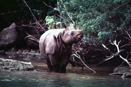
It is also one of only two homes of the critically endangered Javan Rhinoceros. A population of fifty to sixty live in Ujung Kulon.
Within the last 10 years there are 14 rhino births identified using camera and video trap. After several identified calves were males, so at last there are a female calf documented and it means it will ensure that the population is viable. Since February 2011, video and camera trap management will be fully conducted by Ujung Kulon National Park Authority.
The park protects 57 rare species of plant. The 35 species of mammal include Banteng, Silvery Gibbon, Javan Lutung, Crab-eating Macaque, Leopard, Java Mouse-deer and Rusa Deer. There are also 72 species of reptiles and amphibians, and 240 species of birds.
The status of crocodilians within the park is largely unknown- sightings are rare, but do occasionally occur. There are reports of the false gharial within the park, but these are not confirmed. In addition, the saltwater crocodile was historically present throughout Java's coastal river systems but is currently extinct within these regions. Small, isolated populations of the saltwater crocodile are reported to exist within Ujung Kulon but confirmation is needed.
The Ujung Kulon Nature Reserve has been established in 1958 followed by the Gunung Honje Nature Reserve in 1967. Ujung Kulon National Park has been established in 1992. In 2005 the park has been designated as an ASEAN Heritage Park.
Overnight in Ujung Kulon National Park in Camping Ground with Tent, serve Lunch and Dinner, Sea Food, Barbeque and Local Food.
After breakfast at 8:00 a.m direcly to Pamijahan Beach by 4X4 wheel drive car with the wiew of south coastal and country side panorama by a nice landscape and nature.
The sea turtle preserve in Pangumbahan Beach (Day 3)
 |
| photo : Tri Iswanto |
Destination:
7°22,406'S 106°24,049'EPangumbahan Turtle Park is located in Cibuaya, Ujung Genteng, Ujung Genteng is what coastal preservation should be all about. In stark contrast to the beach resorts in places like Bali, there are still goats and cattle running up and down the beach, and the roads have yet to be fully paved.
The water is clear and blue and the sand is powder-white. There is an old Japanese fort in the water at one of the beaches, as well as a sea turtle preserve.
The beach itself is magnificent, still inhabited by sea snakes and monitor lizards, as well as lionfish swimming in the reefs.
 |
| photo : Jefri Aries |
Simplistic and devoid of technology- they don’t even have any kind of computers or testing facilities, yet it performs its function- to preserve a species- admirably and effectively.
It was amazing indeed to see the sea turtles come ashore by the light of the moon, trudge their way almost 100 meters up the beach, dig a hole in the sand, lay over 100 eggs and bury them again.
The eggs are collected in large barrels and constantly monitored by security to protect them from the threat of egg collectors.
 |
| photo : Nury Sybli |
However, that is unique is the waterfall Cikaso or Waterfall Cikaso. The distance is about 33 kilometers from the Edge tiles with travel time about 40 minutes.
Waterfall that falls from a height of 30 meters it really gives a view not boring. Water below the clear green waterfall. The depth of around two meters.
Overnight in Pangumbahan in Camping Ground with Tent, serve Lunch and Dinner, Sea Food, Barbeque and Local Food.
After breakfast at 8:00 a.m direcly to Bayah by 4X4 wheel drive car with the wiew of south coastal and country side panorama by a nice landscape and nature.
Bayah Banten - Caving , Speleological (Day 4 )
 |
| photo: Tri Iswanto |
Bayah located on the south coast of Java island and its beautiful beaches is an interesting tourist attractions. there are several beaches in Bayah, namely Bayah beach, Pulomanuk Beach, sawarna beaches, Tanjung Taraje Beach, Tanjung Karang beach, Ciantir and others.
 |
| photo : Tri Iswanto |
Cilauk Cave
location in Lebak Tipar
This cave is located 5 km from Simpang Wangun and trips taken by tracking. This cave is an underground river cave.
Location in Mt. Curi
This cave is a vertical with a depth of 40 meters, this cave entrance diameter of 3 meters and has a depth of approximately 35 m. And this can be found in the chamber cave. In this cave there is a very narrow hallway and just enough to fit a body and a thin oxygenated.
Cilalay Cave
Location in Mt. Curi
This cave is a horizontal cave. Explorer only takes approximately 2.5 hours. This cave has see-through tunnel and if we look at the bottom there is the river that flows there in.
Cijengjeng Cave
Location in Mt. Curi
This cave is a vertical cave with a diameter of 5 meters at the entrance of the cave. And has a depth of approximately 10 meters. In cave have a chamber cave which diameter approximately 15 meters.
Sawarna Beach
Ciantir Coast District Sawarna Bayah Lebak district, is a very beautiful beaches and attractive, with a distance of approximately 150 km from Rangkasbitung. Offers stunning beaches with spectacular waves are perfect for enjoying your surfing sports, and has become a new paradise for surfers.
Ciptagelar Village - Motocross (Day 5)
 |
| photo : Tri Iswanto |
S 06° 47' 10,4" E 106° 29' 52’’
Ciptagelar Village
According to the kasepuhan belief system, the surrounding forests are the source of life. They recognize three forest types, the basis of their way of forest conservation, as follow:
The ancient forest, called leuweung kolot or leuweung geledegan, is a dense or geledegan forest of large and small trees home to various kinds of animals.
The exploited forest, called leuweung sampalan, is where people establish their farms, tend cattle and collect firewood.
The forest, which they call leuweung titipan is a forest traditionally recognized by all the members of the kasepuhan as sacred. It is not to be exploited without the approval of the foremost leader of the community, the sesepuh girang.
 |
| photo : Tri Iswanto |
The cultivation of this forest is only possible if a message of permission is received from the ancestors through the sesepuh girang. In this way, this sacred forest is continuously maintained. The leuweung titipan around southern Sukabumi is located on Mt. Ciawitali and Mt. Girang Cibareno.
Villagers of Desa Cipta Gelar for three years. And though the rice is grown using traditional methods, without pesticides or chemical fertilizers, there has never been a crop failure in the history of the Kasepuhan; the harvest is abundant every year.
Villagers of Desa Cipta Gelar for three years. And though the rice is grown using traditional methods, without pesticides or chemical fertilizers, there has never been a crop failure in the history of the Kasepuhan; the harvest is abundant every year.
Cross country ride by Motocross form Pangguyangan village to Citagelar Village. these motorcycle pass on steep roads, we finally stopped at a small river that crossed the road. We got off and rinsed ourselves with the ice-cold water. Overnight in Ciptagelar Village . Serve Lunch and Dinner Local Food.
After breakfast at 8:00 a.m direcly to our start point before by Motocross, and direcly to Citarik, Sukabumi by 4X4 wheel drive car with the wiew of south coastal and country side panorama by a nice landscape and nature
After breakfast at 8:00 a.m direcly to our start point before by Motocross, and direcly to Citarik, Sukabumi by 4X4 wheel drive car with the wiew of south coastal and country side panorama by a nice landscape and nature
Rafting - Sukabumi (Day 6)
 |
| photo : Jefri Aries |
S 06° 54' 90,2" E 106° 36' 72,2"
Rafting or white water rafting
is a challenging recreational outdoor activity using an inflatable raft to navigate a river or other bodies of water. This is usually done on white water or different degrees of rough water, in order to thrill and excite the raft passengers.It is considered an extreme sport.
Like most outdoor sports, rafting in general has become safer over the years. Expertise in the sport has increased, and equipment has become more specialized and increased in quality.
The Citarik River which is located in Sukabumi is one of the most well-know rivers for exciting rafting in Indonesia.
Location : Citarik River, Sukabumi
Starting point : Pendopo Cigelong Village
Put in : Parakan Telu
Take Out : Desa Cikadu Village, Palabuhan Ratu
Distance : 17 Km, approximately 5 hour
Overnight in Citarik in Camping Ground with Tent, serve Lunch and Dinner, Barbeque and Local Food.
After breakfast at 8:00 a.m starting rafting and Lunch in Pelabuhan Ratu , at 3.00 p.m direcly to Puncak, Bogor by 4X4 wheel drive car with Hilly side panorama by a nice landscape and nature. Overnight in Pucak, Bogor
Paragliding - Puncak, Bogor (Day 7)
 |
| photo : Didit Majalolo |
6°42'6"S 106°59'2"E
Paragliding is a recreational and competitive flying sport. A paraglider is a free-flying, foot-launched aircraft. The pilot sits in a harness suspended below a fabric wing, whose shape is formed by its suspension lines and the pressure of air entering vents in the front of the wing.
In light winds, some minor running is common. In moderate to medium headwinds, the landings can be without forward speed. With strong winds even going backwards with respect to the ground, but this would usually mean that the conditions got too strong for that glider.
Additionally, at around 4 meters before touching ground, some momentary braking (50% for around 2s) can be applied, then released thus using forward pendular momentum to gain speed for flaring more effectively and approach the ground with minimal vertical speed.
 |
| photo : Didit Majalolo |
Paragliding take off Area is above tea plantation area, on elevation 1345 meters sea level, it has beautiful view, this take off area we called it Bukit Gantole or Hang gliding Hills in english.
After breakfast at 8:00 a.m starting paragliding and Lunch in Puncak, at 3.00 p.m back to Jakarta by 4X4 wheel drive car
Subscribe to:
Posts (Atom)